Introduction
If you think the Netherlands is just cities like Amsterdam and flat polders filled with tulips, think again. In the East of the Netherlands there are huge areas of sandy woodlands. If  you cycle north of Wageningen for just ten minutes you are in the woods, and you can then cycle, off-road, for hours, with large areas of forest, heathland and inland dunes. You are in the Veluwe, an area popular with Dutch tourists, but little-known outside the Netherlands. For part of the area there are few restrictions on where you can go. You do not have to stick to waymarked tracks (although they do exist if you prefer that). There are restrictions south of Wolfheze (where there are vulnerable areas with rare plants and animals) and the Utrechtse Heuvelrug (the moraine area west of Veenedaal and North of Rhenen), where mountain bikers are restricted to the official routes apparently because of the high recreative pressure on the area. The military zone of the Ginkelse Heide has restricted access and in parts of the Renkumse Beekdal mountain biking is not allowed. Look out for the signs!
This site has a blog, which is normally updated every couple of weeks (you can subscribe from the RSS link at the bottom of this page or mail to mtb {at} andrewspink.nl. The most recent item is always shown on this page. There are also some pages about where you can go on your mountain bike near Wageningen, and some other information. If you want to contact me with comments or suggestions, please see the About page.
De Hattemer Herfst ATB tocht 2023
Hattemer is just a bit too far away from Wageningen, so I had never been on their tour before. I guess that is so for more people, because I heard that there were only 250 participants. We usually get at least twice that for the tours we organise in Wageningen. However, last Saturday I was on holiday nearby and joined the tour. I and all the others who not normally take part in the eight previous editions had definitely been missing out on something special.
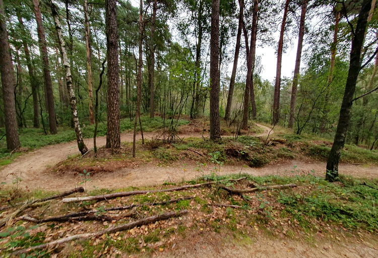
It was a great route, through a diverse and varied landscape. It started off from the ice skating association clubhouse (it was cool, but not that cold) and for the first few kilometres we could warm up as we cycled on the road. Then the route branched off into the woods and the fun started. We went through all different sorts of woodland; conifers, broadleaved and mixed, with occasional stretches of heathland and grassland. After that first bit, and a short stretch at the end, almost none of it was on asphalt. Because the landscape was varied, so was the soil, we went from loose and slippery sand (I was very happy it had rained heavily the night before, or it would have been really hard work indeed) to grippy loamy forest soil. There were a few small hills, leading to a total of about 300 m of climbing.
Due to the time of year, when we set off, there was some mist in the forest, which gave some spectacular effects with the sunlight coming through the trees.
[text continues under the photo]

We were very luck with the weather. Not only did the rain the night before mean that it was all rideable, but it was not too hot and not too cold (aside from the first half hour, when I needed a jacket, dry, and quite a lot of sunshine.
It was a well-organised tour, with a great atmosphere ('gezellig'), clear signing and two breaks, which was generous for a tour of only 45 kms.
So far as I could see, the route is all on tracks that are normally open, so you can follow it from here. But ff you are in the area next September, it is definitely worthwhile to join the tour and support the club that organises it.
Rheden kinderroute
The Rheden mountain bike route has a number of extra bits tacked on, mostly quite technical. One of those is the 'kinderroute'. Despite the name ('kinder' is children), it is certainly not only a route for children. It has a lot of tight bends and curves, which makes it suitable for small bikes. However, that also means that it is a really good practice of your steering skills if you are on a full-sized bike, especially one with modern 29-inch wheels.
[Text continues under the photo]
There is also plenty of up and down, and a few drop-offs as well. Some are on the regular route, and for other, larger ones, there are a few little diversions, marked with an open (not-filled) MTB icon, indicating a harder alternative.
It is on very sandy soil, and that means that, with the recent dry summers, there is always the problem of loose sand and erosion. The track maintenance crew have done a lot of work in embedding wire mesh into the track to prevent this. However, there are still some treacherous patches left, which you need to look out for.
All in all, an enjoyable and challenging small route. Perfect as an addition to the longer Rheden route, or (like I did this morning) as a quick breath of fresh air before leaving for home at the end of your holiday. It is worth riding twice as the second time round you know what is coming and can take those corners just that little bit faster.