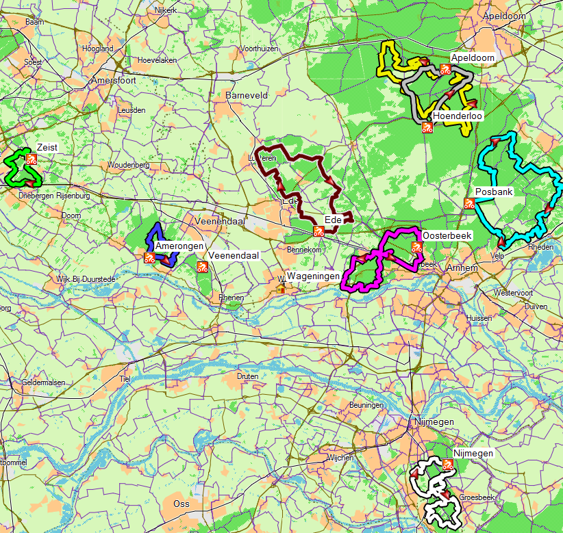
Official routes
This page lists the official mountain bike routes near to Wageningen. You do not have stick to those, you can also use unmarked tracks (click the Routes menu for some suggestions). There are restrictions in 2 areas near Wageningen, south of Wolfheze (where there are vulnerable areas with rare plants and animals) and the Utrechtse Heuvelrug (the moraine area west of Veenedaal and North of Rhenen), where mountain bikers are restricted to the official routes apparently because of the high recreative pressure on the area.
The routes are given as GPX files. This is a standard format for interchanging GPS infromation. Save them to your hard disk by right-clicking the link and then open them in e.g. Google Earth or with the GPS Visualizer website or Base Camp. The tracks are reduced to a maximum of 500 points (which is a limit for uploading to some GPS devices).
| Route | GPX File (right-click; save as) | Notes | More information (Dutch) |
| Rheden (Posbank) |
The best route in the locality, 52 km with varied terrain in woodland and heathland and quite some differences in height. The gpx file here is from the nearest starting point to Wageningen; other starting points can be found from on mtbroutes.nl. The route is changed slightly from time to time, so you also need to pay attention to the boards. Note that you need to buy a permit. You can get it from the Natuurmonumentum visitors' center. Read more |
mtbroutes.nl | |
| Oosterbeek | Oosterbeek.gpx |
You can start cycling from Wageniningen. The route is 36 km with a possiblity to cut it short. To reach the start from Wageningen you can best go through the woods by Oranje Nassau Oord, go along the road past the paper factory by Renkum, then over the floodplain to join the route. Blog article... |
mtbroutes.nl |
| Veenendaal | Veenendaal.gpx |
Very short route (3 km), However can be combined with other nearby sites. Although it is close to Veenedal, it is officially in Rhenen. |
mtbroutes.nl |
| Nijmegen | Red route Green route Red and green |
The green route is 18 km and the red route is 24 km. They are joined at 2 points to give a total length of 43 km. This route is number 3 in the top 10 routes from the Netherlands. Blog article... |
mtbroutes.nl |
| Amerongen | Amerongen.gpx |
This 15km trail is in the process of being renewed, and is greatly improved compared with how it was earlier. See http://www.mtbroutes.nl/route/601/Amerongen for the most recent route, and note it is changing all the time. Note that if you do not buy a permit, you risk getting a fine! Photo |
mtbroutes.nl |
| Rhenen | Rhenen.gpx | This is a new route, and although not so long (7 km) it is great fun and can be combined with Amerongen. Note that if you do not buy a permit, you risk getting a fine! Read more... | mtbroutes.nl |
| Ede | Ede.gpx |
39 Km in woodland and heathland. Part of the route can easily be combined with other routes starting from Wageningnen. |
mtbroutes.nl |
| Hoenderloo | Hoenderloo.gpx | 23 km in woodland and some heathland. Typical Veluwe with small hills and, sandy woodland. Off the top of the map below, but only 1/2 hour drive from Wageningen. Note that the GPS track is different from the paths indicated with the international MTB signs there. | mtbroutes.nl |
| Apeldoorn | Apeldoorn.gpx | 50 km in sandy forest. Note that the GPS track is different from the paths indicated with the international MTB signs there. Read more... |
mtbroutes.nl |
| Zeist | MTB Zeist.gpx | 17 km in sandy forest, very twisty, lots of short-steep inclines. Read more... | mtbroutes.nl |
| Montferland | Montferland.gpx | 26 km, hilly, mixed forest. East of Arnhem (not shown on map). Read more... | mtbroutes.nl |
For a route planner for cycling on cycle paths between two addresses, see the routes page.