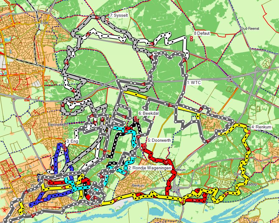
Mountain bike routes near Wageningen
For much of the area around Wageningen there are few restrictions on where you can go on your mountain bike. You do not have to stick to waymarked trails (click the Trails menu if you want to see those). There are restrictions in 2 areas near Wageningen, south of Wolfheze (where there are vulnerable areas with rare plants and animals) and the Utrechtse Heuvelrug (the moraine area west of Veenedaal and North of Rhenen), where mountain bikers are restricted to the official routes apparently because of the high recreative pressure on the area. In the Renkumsebeekdaal there are some areas where it is also forbidden to cycle in the woods, and these areas are signed, plus the Ginkelse Heide is also largely restricted. These restrictions change from time to time, so it is always possible that the routes below include paths which were allowed when I posted them, but are now forbidden, so please keep an eye out for signs.
The routes are given as GPX files. Save them to your hard disk by right-clicking the link and then transfer them to your GPS device. The tracks are reduced to a maximum of 500 points (which is a limit for uploading to some GPS devices).
| Map | Route |
GPX file (right-click; save as) |
Notes |
| 1 | Winter route from the Wagenignen Tour Club |
WTC Tour.gpx |
52 km along one of the tours organised by the Wageningen Tour club in November 2009, mostly in woodland. |
| 2 | Wageningen Rondje |
Wageningen Rondje.gpx | One hour circuit round Wageningen (14 km), ideal for a summer evening |
| 3 | Wageningen Eng |
eng.gpx |
Quick circuit next to Wageningen (10 km, roads) |
| 4 | Renkum |
Renum.gpx |
From Wageningen to Renkum, Doorwerth, Wolfheze and back through the woods at Oostereng. 37 km. |
| 5 | Doorwerth & Renkumsebeekdaal |
Doorwerth.gpx |
To Doorwerth and back via Renkumsebeekdaal. 25 km. |
| 5b |
Doorwerth (alternative route) |
Doorwerth2.gpx |
Longer (35 km) variant of the above route. |
| 6 | Renkumsebeekdal |
beekdal.gpx |
One hour circuit in the Renkumsebeekdal (15 km) |
| 7 | Sysselt and Gikelseheide |
Sysselt.gpx |
30 km; through the woods to the Ginkelse Heide (heath) and back through the Sysselt woodland. |
| 8 | Default route | default.gpx |
Towards the Ginkelse Heide and then back through the Sysselt (33 km) |
Route planner (on cycle paths and roads)
Translation:
Van = From
Naar = To
Makkelijke doorfietsen = Fastest but not necessarily the shortest, few traffic lights
Kortse route = Shortest route
Racefiets route = Suitable for racing bikes, good surface, recreative
Recreative route = Nice views, where possible without cars nearby
Natuur route = As much as possible in the countryside, few cars, green
Autoluwe route = Cycle paths separate from roads with cars, few traffic lights
Netwerk fietsknooppunten = Routes between notice boards with numbers aimed at recreational cyclists, in between 'makkelijke doorfietsen'
Netwerk landelijke fietsroutes = National 'LF' routes, in between 'makkelijke doorfietsen'
Combinatie fietsnetwerken = Combination of the above two
Routetype advancerde = Define your own preferances