Blog

Montferland
It was about 8 years ago that I last cycled the Montferland route. That was a memorable occasion, not so much because of the splendours of the route as for noticing a left turn at the bottom of a steep hill slightly too late and jamming my brakes on, whereupon my front wheel dug itself into some soft dry sand, flinging myself over the bike, resulting in some broken ribs and a few months recovery off the bike.
So it was with some trepidation that I ventured out on the Montferland route last Saturday, together with the club. However, it soon became clear that not only was there not a grain of dry sand to be seen (on the contrary, everything was extremely wet) but that apparently I've picked up something about how to handle a mountain bike in the past few years, as none of the hills looked particularly scary. That's not to say that all the downhills were easy, quite some braking was needed, but the difficulty was more to do with the severe erosion caused by the rain of recent weeks, which meant that there were some significant holes and in places a remarkable sort of corrugated surface. It was the only time since April when I had the feeling that my hardtail was not always an improvement on my old fully. But I'm certainly not complaining about the maintenance of the trail. The signposting is perfect and even where the trail is so wet as to qualify as flooded, the ground is still hard enough under the surface to make it passable. Well, mostly. On one occasion I was trying to avoid broadening the trail still further, so ploughed through the middle of a puddle, only to end up with the front wheel sinking up to its axle in the mud, bringing me to a complete halt. No flying over the top this time though, just damp feet. The trail maintenance is paid for by buying a permit, which can conveniently be done from a bike shop near to the start. The price of the permit has more than doubled in the recent years, which I don't mind so much, though I do think that paid-up members of 'natuurmonumenten', which is the responsible organisation, ought to get a discount.
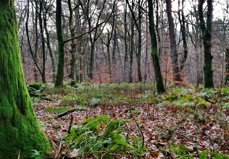
Anyway, bottom line is that it is a great trail. Although it is only 26 km long, the 450 height meters, some of them reasonably steep, make it feel like more (at least if you're used to the relative flatness of near Wageningen), the woodland is diverse with quite a few different tree species and a well-developed understory (plenty of bracken and other ferns) and, so far as I could see whilst whizzing past on the bike, a fine selection of mosses (the tree in the photo is covered in an attractive layer of Hypnum cupressiforme var. filiforme). Parts of the trail are only a few meters from the German border, and the landscape indeed looks quite different, giving a bit of a holiday feel to it. What more could you want?

The best 7.50 I ever spent
In recent years the trails on the Utrechtse Heuvelrug (the sandy moraine between Utrecht and Wageningen) have undergone a transformation. Routes like Amerongen used to be ok, but with quite a lot of long straight bits and not very challenging. That's all quite different now. A new route has been created at Rhenen, and more recently the Amerongen route has been largely remade. Last Saturday we cycled the Rhenen route and half of Amerongen (setting off from Wageningen the whole of the Amerongen route was too far for all but two of us). It really was great fun, with swooping descents and steep ascents making the best of the differences in height and tight curves demanding substantial focus and concentration on your steering. At at few points I really wondered if my handlebars would fit through the tight gap between the trees (they did). They have also built in a few small jumps (with alternatives in case you don't want that) for extra fun. Even cycling back to Wageningen had its good points, despite the asphalt, we had to thread our way through a herd of sheep (an unusual occurrence in these parts) and some of us were lucky enough to see a kingfisher. 
Practical points
You can buy the permit for all the trails on the Utrechtse Heuvelrug from the shops and other points listed here: http://www.mtb-utrechtseheuvelrug.nl/vergunning/, plus from Roel Perenboom's shop in Wageningen. Note that you cannot buy one in Rhenen, nor via internet. Fines are regularly dealt out to mountain bikers without permits or if you do not stick to the waymarked trails. Development is continuing, which means that the GPS tracks on the internet (this site, the Heuvelrug site and mtbroutes.nl) are often out of date at the moment. On the connecting route between Rhenen and Amerongen, there is an off-road section only when you are going East; going West you stick to the road. The signposting is exceptionally good and clear, so that really does not matter. Do pay attention to going in the right direction, large sections are real singletracks where there is no room for people to go two ways.
Mountain biking in the Rureifel

This morning I headed out into my local woods in the hope that I would be back before the storm started. That was of course hopelessly optimistic and before too long I was reminded of the last time I was out in torrential rain, in the Rureifel this summer. The Rureifel is the bit of the Eifel nearest to the Netherlands, just a few kilometres south-east of Aachen and very close to the Belgium border, by the national park Hoge Venen/Hautes Fagnes. However, the landscape is surprisingly different from all those areas and also quite different from other areas of the Eifel, like the Chalk Eifel. It is excellent mountain biking terrain, with something for everyone, ranging from relatively easy (but beautiful) circuits around the lakes which were formed by damming the river, to quite substantially steep slopes like the ones shown in the above photo. Meyer & Mommer's excellent book, 'Mountainbiken in der Eifel' has got 6 tours in the region, starting in Nideggen and in Simmerath (but of course you can start half way along, at the point closest to where you are staying). Tour 14 was the best in my opinion. It is both challenging (the maximum of five stars for condition and for technique as well as 1300 height meters) and includes an assortment of stunning views. You can download the GPS here, view the track here, or get it from GPSies here. An area which is not covered in that book, probably because it has only recently been opened to the public is the 'Dreiborner Hochfläche" by 'Vogelsang'. This was a military zone until quite recently, which means that they are strict about you staying on the trails. The mountain bike routes include significant climbs and descents, but they are not so technical. However, the adjacent footpaths are more interesting, and when we were there with very few walkers. It is certainly well worth exploring and has a wilder feel about it than the carefully managed forests elsewhere. We had avoided this area of the Eifel for many years under the impression that it would be unbearably touristy. We were staying next to the pretty village of Heimbach, which is indeed full of tourists, but like a lot of places, as soon as you cycle more than 5 minutes away from the road you can go for hours with barely seeing a soul. The Rureifel was certainly worth a visit and I'm sure we will be back.
Brushing-up on my mountain bike skills
This week, instead of our usual tour through the woods, our group from the club had a clinic to teach or remind us of the basic skills, led by the inestimable Marc Kuster. For some of us it was new information, and for others it was a matter of reminding us of how it ought to be done and trying to discard bad habits picked up over the years. We spent most of our time on a flat piece of grass and then in and round a big hole in the sand. The GPS tracks show that we went round and round in circles.

Sounds boring? Far from it! It was in fact quite challenging, and we all agreed we had gained a lot from it. We spent most time weaving in and out of traffic cones to learn how best to control our position on the bike so that we could manage to turn in apparently impossibly tight bends. Then we covered hopping over logs before moving on to the sand pit where we found some steep slopes to climb up and down in a controlled fashion. So far it was for me mostly a matter of remembering to do it properly and above all being bothered to get out of the saddle for that greater degree of control. But right at the end we had a go at a drop-off which was just big enough to be a little out of my comfort zone (i.e. not very big at all really). The first time I went over it I sternly told my fingers to stay off the brake levers, but they paid no attention and I slowed down more than was a good idea. Nevertheless, I still had enough momentum to carry me over without problems. The second time I know it was possible, so I could keep going without thinking about braking, which also meant that I could focus more on my position on the bike, so that went a lot more smoothly. And then the next time it was not even scary! They say that it is good to do a clinic like this every so often to brush up on faded skills and I must say that after Saturday I could not agree more. Now I'm eager for one with a little more difficulty, up to the next level! Read more...