Home
Article for home page
Introduction
If you think the Netherlands is just cities like Amsterdam and flat polders filled with tulips, think again. In the East of the Netherlands there are huge areas of sandy woodlands. If  you cycle north of Wageningen for just ten minutes you are in the woods, and you can then cycle, off-road, for hours, with large areas of forest, heathland and inland dunes. You are in the Veluwe, an area popular with Dutch tourists, but little-known outside the Netherlands. For part of the area there are few restrictions on where you can go. You do not have to stick to waymarked tracks (although they do exist if you prefer that). There are restrictions south of Wolfheze (where there are vulnerable areas with rare plants and animals) and the Utrechtse Heuvelrug (the moraine area west of Veenedaal and North of Rhenen), where mountain bikers are restricted to the official routes apparently because of the high recreative pressure on the area. The military zone of the Ginkelse Heide has restricted access and in parts of the Renkumse Beekdal mountain biking is not allowed. Look out for the signs!
This site has a blog, which is normally updated every couple of weeks (you can subscribe from the RSS link at the bottom of this page or mail to mtb {at} andrewspink.nl. The most recent item is always shown on this page. There are also some pages about where you can go on your mountain bike near Wageningen, and some other information. If you want to contact me with comments or suggestions, please see the About page.
Site reconstruction
When I first created this site two years ago, I got the feedback that the content was nice, but the appearance was old fashioned. That was fair enough, but in order to transform the old html site into something a bit more modern looking, I had to have the time to learn how to install and work a CMS system (Joomla) and move the content into that system. Naturally I thought that would only take a few months, and equally naturally it has taken a couple of years. It is the sort of thing you might do on a rainy day, unless you are a mountain biker, in which case rainy days are the days that you have the woods to yourself and go out on your bike. However, a small operation recently has meant that I have several weeks off the bike, which combined with a Christmas break means that finally I have had time to update the site. I hope you like it.
WTC winter tour 1 2012
What I do not understand is how come, of all the 430 mountain bikers on the tour today, I was the only one wearing shorts. It was not cold,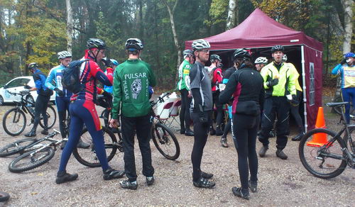 about ten degrees, raining a bit (not too much), and in that weather shorts are so much more practical. No wet fabric against your legs. It was beautiful today, with the autumn colours really spectacular (especially if you wore glasses with yellow lenses!) and as usual with such tours a really nice atmosphere with all the people taking part. Unfortunately I've still not 100% recovered from the 'flu I had a few weeks ago, so had to limit myself to the 30 km route. I set off sure that at least the medium length of 45 kms would be no problem, but I was already tired by the coffee break (left). As usual the Tour Club Wageningen did an excellent job of organising it, signposting and everything else perfectly done.
Read more (in Dutch)
350 m
Although it is pretty flat round here, that does not mean that there are no hills at all. 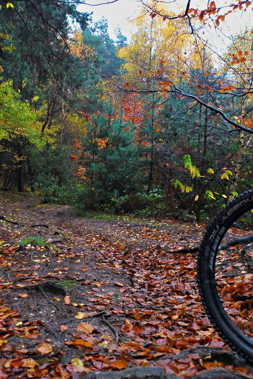 The river Rhine slices through a couple of glacial morraines, which means that at a few places there is a relatively steep hill going up from the floodplain onto the land above. One such area is near Doorwerth, which is about ten kilometers upstream from Wageningen. I had not been that way for a while, but today I thought it was time to see if my flu really was completely vanquished, so the slopes there would be a good test of that. By taking a route which went up and down the morraine edge a number of times, I had 350 height meters in a distance of 35 km (or in fact, 350 m in much shorter as most of the 35 km was going there and back). The slopes are not so super steep, about 12% at most, but they are made of loose sand (not so such a problem today as it was raining), with difficult roots. Normally I choose a route which is not so steep going down as then you get a nice long downhill swoop, but today everything was covered in a thick layer of leaves, so I had to go fairly cautiously as I had no idea what sort of logs or holes might be lying in wait for me under the pretty autumn leaves.
HDR
Bright sunglight shining through the trees is very difficult to photograph, even with an DSLR, and with a phone it is almost impossible.  The sun is too bright and the silhoutettes are too dark. When you are out on the mountainbike in weather like today, it a problem. There is a solution, and it is called HDR, or high dynamic range. You take one photo correctly exposed, one that is over-exposed (but that one has some detail still in the shadows) and one that is under-exposed (but in that one the sky is not too burnt out), and then combine them. Normally you would do this with a DSLR (so you can create RAW files, which have much more contrast range than a jpeg) and a tripod, so that all the photos are of exactly the same scene. Then you combine them with software like Picturenaut. With just a phone in your rucksac, you need another solution. The solution is an app (HDR Camera) which automatically takes 3 exposures, aligns them and creates an optimal image. I still have to play with all its settings, but judging by the photo on the left, even with default settings it can do a good job of an impossible situation.